 The Historic Corn Trail
Introduction
This trail is a 12.5km walking and horseriding track through the Buckenboura State Forest, winding from the top of the Clyde Mountain down to the head of the Bolero Valley. It was first pioneered by the settlers of the valley to trade produce with their neighbours on the Southern Tablelands. The major crop from the fertile valley was corn which was transported by pack-horse to the towns of Araluen and Braidwood.
 The trail was also used to bring cattle down from the tablelands for agistment on the coast and also by gold prospectors.The trail was the first link between the coast and tablelands but by the 1920s was overgrown after another route over the Clyde Mountain had been opened in 1854.
The Corn Trail was reconstructed as a bicentennial project and is now safely accessible, giving you the chance to experience the rich history of our coastal pioneers and the scenic beauty of the wilderness.
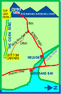
It is highly recommended that you walk the trail from top to bottom, arranging to leave your vehicle or to be picked up from the bottom carpark on Misty Mountain Rd. Allow a minimum of 6hrs depending on your fitness. It is also recommended that you carry food and water. As the weather in these environs can be quickly changable, you should also carry warm and waterproof clothing. The top of the trail which is 800metres above sea level can often be misty. Please take all garbage away.
Maps of the trail are available from the Batemans Bay Visitors Centre and the Batemans Bay Forestry Office.
The following article by the late Dennis Moore, local explorer and tour operator, gives an indepth appreciation of the beauty and interest of this wilderness walking adventure.
The Corn Trail
A narrow pack-hose trail across the mountains of the coastal NSW escarpment has been granted new life. Known as the 'Corn Trail', it linked the south coast to the Monaro Plains when roads for wheeled vehicles were a far off dream.
Today's informed sightseer, hiking along the Corn Trail might wonder to what extent a traveller of the 1830s would have been moved to marvel at the grandeur of his surroundings. Would a horseman of the pioneering years have considered the immensity of achievement involved in carving a trail by hand up a rainforest filled gorge, then across the mountain barrier separating the coast from the Braidwood plains?
On the ascent today, looking at the formidable, steeply rounded hill tops, there is relief in the knowledge that the trail ahead remains a simple, steady climb. But while the trial itself is not hard, the country traverses grades from steep to precipitous, and one missed step could result in a plunge to oblivion. The nature of the terrain means the walk should not be lightly undertaken, as rescue could take days, not hours. The main climbing section on its own, ascending 600 metres from the Buckenboura River to the plateau, takes two hours - for an experienced, healthy hiker without pack.
 At its upper end the restored Corn trail commences with a disused vehicular track winding southward along a gently rounded montane plateau. Gaunt, dead trunks of silvertop ash (Eucalyptus sieberi), killed by bushfires, are surrounded by many black trunked grass trees (Xanthorrhoea australis). The sombreity is broken by everflowering coral heath (Epacris impressa) among the many spring wildflowers. Hairpin banksia (B spinulosa) is widespread, and there is also much less common Banksia canei, a species restricted to this type of montane area.
Next the trail leaves the old wheel ruts behind to dip eastward across the rim of the plateau before swinging south again and down. Here there are dense thickets of tristania and a little dry temperate rainforest. The crowded, spindly stems of tristania required much clearing to make the trail passable.
The vast bulk of Mount Budawang can be seen here, as well as sandstone peaks, including Pigeon House and Castle Mountain further north. To the east, various parts of the coastline and foothill ranges are discernable.
The Corn Trail ridge slopes away southward in a series of rounded hill tops, and it is here that the early trail builders displayed bush engineering skills in laying out the route. Reasonable grades were maintained by side cutting to the east or west of each hill, or by zigzagging downwards in one tight switchback or another. Views to the west are across the Buckenboura Gorge and the cleared farmlands of the lower Buckenboura Valley are glimpsed to the south.
The heavily barked and often scorched silvertop ash trees, which dominate the exposed ridge, mingle with more attractive mountain grey gums (E cypellocarpa) as the surrounding mountains tower higher and the trail descends. To the east, rainforest growth appears in a tributory gully, and as sounds of water gurgling amoung boulders drift upwards, the trail drops to the main valley floor.
 Coachwood (Ceratopetalum apetalum), sassafrass (Doryphora sassafrass) and grey myrtle (Backhousia myrtifolia) form a closed canopy above tall tree ferns. Hanging vines, ferns and mosses impart a cavern like aura. The crystal, sparkling waters of the Buckenboura are irresistable to dry throats.
From the lower carpark, the Corn Trail commences by crossing the Buckenboura, then climbing tortuously for a few moments among the large, mossy boulders. It continues upwards by way of a medium slope before diverging north to traverse the hillside, for a time climbing further above the valley floor. This portion of the trail, west of the river, passes through forest from which hardwood logs were harvested in 1983. Regeneration of eucalypts and lower storey shrubs is rapidly obliterating traces left by the timber cutters. The valley ahead narrows and plunges into the gorge too steep for logging.
 The trail winds on among gullies and through hairpin corners which cross tiny creeks. Traces of rainforest become narrow belts until the trail at last descends beneath the rainforest canopy to the valley bed. This interlude is enchanting, and seems all too brief. A small open clearing is the remains of an old campsite and rest area where men and animals prepared for the principal uphill section. Near the campsite, the stream is crossed again, and soon the big climb has commenced. The trail winds on among gullies and through hairpin corners which cross tiny creeks. Traces of rainforest become narrow belts until the trail at last descends beneath the rainforest canopy to the valley bed. This interlude is enchanting, and seems all too brief. A small open clearing is the remains of an old campsite and rest area where men and animals prepared for the principal uphill section. Near the campsite, the stream is crossed again, and soon the big climb has commenced.
The Corn Trail is a priceless slice of heritage. Its main sections remain as pristine as the day the first European made the crossing. The only interference with the natural environment is the trail itself , and under Forestry Commission management, timber cutters never reached the rainforest or principal ridge. As a trail not suitable for wheeled transport, it was seldom used after 1856, when the dray trail from the Braidwood plains to the Clyde River at Nelligen was made passable. Resurrection of the old pack trail is a commendable achievement.
Like many things, the earliest use of the Corn Trail is not to be found in existing records. However, there is excellent reason to believe it was the first trade link between NSW coast south of the Shoalhaven, and the Monaro Plains.
Recorded development of the area east of the escarpment commenced in 1828 with the visits of surveyors Robert Hoddle and Thomas Florence. During June 1828, Florence noted a 'deserted bark hut and stockyard'. This was beside the Buckenboura River, which Florence referred to as the MacLeay's River, a mile or so upstream from its junction with the Clyde River.
 The clear, fresh water of the Buckenboura almost reaches the navigable waters of the Clyde, and along with fertile river flats, must have been a motivation for settlement. Convict labour was used to clear the lower valley flats and slopes of the Buckenboura upstream to the Bolero, as well as its tributary, Mullendaree Creek. The convict brick kitchen beside Runnymede House, near the river crossing at Runnyford survived the fire which destroyed the original homestead. Along with the old cellars under the reconstructed house, it is an important relic in urgent need of preservation listing. The clear, fresh water of the Buckenboura almost reaches the navigable waters of the Clyde, and along with fertile river flats, must have been a motivation for settlement. Convict labour was used to clear the lower valley flats and slopes of the Buckenboura upstream to the Bolero, as well as its tributary, Mullendaree Creek. The convict brick kitchen beside Runnymede House, near the river crossing at Runnyford survived the fire which destroyed the original homestead. Along with the old cellars under the reconstructed house, it is an important relic in urgent need of preservation listing.
It was from this pocket of pastoral settlement that the Corn Trail headed towards the Braidwood plains. Other trails across low foothills connected the Buckenboura Valley to developing areas at Moruya and Broulee. Whilst coastal shipping was providing the vital link binding the south coast to Sydney, the Corn Trail offered new opportunities for trade between the coast and the upper Shoalhaven valley, and to the Monaro.
It is likely that local Aboriginal tribesmen first showed white settlers the ridge which could be followed to the top of the montane plateau, above the easier slope westward to Monga Flat. Probably already passable for experienced horsemen, the trail was improved by side cutting the easier gradients to make it suitable for loaded pack animals.
During work on the trail, it was discovered that in many places excavated sections had been superseded by later side cutting and at times it was only after long discussion, analysis and debate, that the optimum route for reconstruction could be decided. Other sections were obviously the original and only feasible means of passing.
The Corn Trail preliminary research and actual rebuilding was carried out by the Historic Tracks Research Group, including over 400 members, among whom Ricci Simpson, Peter Mass and Charlie Bond were key personnel. The group was formed to rebuild the Corn Trail as a bicentennial project, and a grant was received from the Bicentennial Authority. Substantial help was also given by the NSW Forestry Commission, who constructed the access roads and parking areas.
The Commission also arranged for the trail to be totally protected by a Preservation order under their preferred management priority classification system.
Ricci Simpson said that the reason the Historic Trails Research Group was formed was to make a safe walking track which could be enjoyed by everyone who is reasonably fit and healthy.
The entire project took four years, and as a preliminary measure, the group scoured the entire area looking for any form of old cutting. Ten months actual construction time was necessary to build the lower six kilometres, while the top section was completed in only two months.
Access roads to the upper and lower parking areas are well signposted, but certain sections after rain are likely to be suitable only for four wheel drive vehicles. Up to date information should be obtained fron the Forestry Commission's Batemans Bay District office by any group which intends to inspect or hike the Corn Trail. Motor bikes are prohibited from using the trail.
The trail, therefore, is once again in use, and the beauty of the NSW south coast terrain can be appreciated from the Corn Trail.
Read further interesting historical accounts of our past.
The Dray Trail to Prosperity
Nelligen gold rush days
The Inlet that Eluded Bass
|
Clyde Coast Links

|