coastal views
national parks
rainforests
Egret - SCT

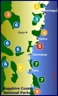
Welcome to the natural and protected beauty of the National Parks of the Sapphire Coast.

Click to return to Sapphire Coast Tourist Top Page

Sapphire Coast National Parks mud map


Photo Album
1 Wallaga Lake National Park
2 Wadbilliga National Park
3 Biamanga National Park
4 Mimosa Rocks National Park
5 Bournda National Park
6 South East Forest National Park
7 Ben Boyd National Park
8 Mt Imlay National Park
9 Nadgee Nature Reserve
Beaches


rosella
See an overview of each park by scrolling down through this page or by jumping to specific parks from the list or map above.
Visit the album for more beautiful photos of the National Parks of the Sapphire Coast. You'll see native wildlife and magnificent scenery.


.

Wallaga Lake National ParkMt Dromedary - SCT

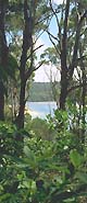
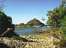
Piles of shells speckle Wallaga's quiet shores. Some of these middens, reflecting continuous Aboriginal habitation are thousands of years old, so please don't disturb them.

Lake fishing is renowned. You can enter on foot from the Princes Highway, but it is best accessed by boats, which can be hired from Regatta Point or Beauty Point.

Mt Dromedary (Gulaga) is always in the background.


[ Map ]


.

rainforestWadbilliga National Park
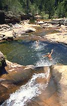
Wadbilliga is a mountainous wilderness cradling one of NSW's largest undisturbed river catchments. A 3 km walk extends from Cascades to Tuross Falls.

Due to the rugged and relatively isolated nature of the park, animal populations here have remained relatively undisturbed. Swamp wallabies, eastern grey kangaroos, wombats, possums, platypus and echidnas are evident and in places like Wadbilliga Valley are particularly common. There is a diversity of birdlife with 122 native bird species having been sighted here.

Camping is permitted at Lake Creek or Cascades. Picnic at Wadbilliga Crossing.

[ Map ]


.

Biamanga National Park Mumbulla Falls


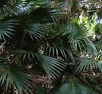
South east of Cobargo, the newly created Biamanga National Park contains vast areas of tall, old-growth forest bordering the Murrah River.

Access is limited. Accommodation locally at Bermagui or Bega.


[ Map ]


.

Mimosa RocksMimosa Rocks National Park
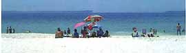
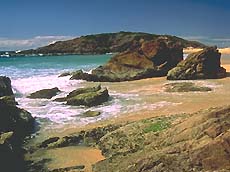
The park features a rugged and scenic coastline with many beaches enjoyed by surfers, fishers, snorkellers, birdwatchers and sightseers. Many natural sculptures occur on headlands, cliffs and rock stacks.

Bushcamping is permitted at Middle Beach, Picnic Point, Aragunnu and Gillards Beach. Fees apply, payable on site. Picnic facilities with barbecues also available.

The park is located 22 km north-east of Bega, off the Tathra-Bermagui Road.

[ Map ]


.

Bournda National ParkWallagoot Lake
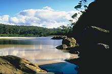
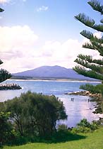
This is a park of great beauty and conservation value, with saltwater and freshwater lakes, a lagoon, creek and beaches. There are many opportunities for swimming, fishing, canoeing and walking with a viewing platform at North Tura and good picnicking by Bournda Lagoon.

Access is from Merimbula and Tura Beach in the south (sealed) or from Tathra in the north (unsealed). Camping is available at Hobart Beach on the southern shores of Wallagoot Lake.


[ Map ]


.

Paper daisySouth East Forest National Park

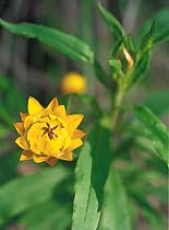
Recently gazetted, this park contains outstanding tall old-growth forests, blooming heathlands, upland swamps, spectacular granite boulders and moist fern-filled gullies.

The South East Forest National Park protects some of the State's more endangered animal species such as the Long-footed Potoroo, Yellow-bellied Glider, Smoky Mouse, White-footed Dunnart, Koala, Tiger Quoll and the Sooty and Powerful Owls.

Scenic drives provide access to picnic areas at Six Mile Creek, White Rock River, Wolumla Peak and Big Jack. Viewing platforms with wheelchair access and boardwalks offer spectacular views across the Bega Valley at Pipers Lookout. Bushcamping is permitted at Six Mile Creek.

[ Map ]


.

Ben Boyd National ParkBoyd's Tower

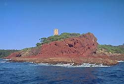
Comprises two rocky and beautiful stretches of coastline north and south of Twofold Bay featuring vivid rock formations, flowering heaths and banksia forest. Don't miss the Pinnacles (red and white earth formations) or Green Cape Light House, the most southerly of the NSW coastal lighthouses.

You can camp at Saltwater Creek or Bittangabee on the south side of Twofold Bay on the Green Cape promotory but you will need to book ahead.

You can enter the northern section of the park on Haycock Rd which leaves the Princes Hwy 8 km north of Eden and the southern section by Edrom Rd off the Princes Hwy 18km south of Eden.


[ Map ]

.

Mt Imlay NP - SCTMt Imlay National Park


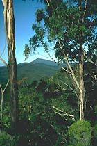
The visitor can enjoy great views of the coast and the forests from the heights of Mount Imlay. The 3 km track from the end of the Burrawang Forest Road is steep and rough but well worth the effort.

The park is rich in bird and animal life including lyrebirds, tree creepers and currawongs with wedge tailed eagles occasionally seen overhead. Rainforest pockets occur in the sheltered gullies within the park.

Turn off Princes Highway 20 km south of Eden, then along Burrawang Road.

[ Map ]


.

Nadgee Nature ReserveNewtons Beach - Nadgee SCT

The reserve contains the only coastal wilderness in NSW and one of the largest undeveloped catchments on the eastern seaboard.

Experience unique coastal walks, including sandy beaches, rocky headlands and spectacular coastal heathlands. Overnight bushwalking permits are required.

On the edge of the wilderness, Greenglade and Baycliff, accessed via Wonboyn Village, offer excellent picnicking, swimming and beach fishing.


[ Map ]


Photo Album


Sapphire Coast Links
accommodation
attractions
sapphire coast
business directory


BACK NavigatorIndex


© Morningside Internet